Location:
- Feature of the month: No.6 November 2009
Feature of the month: No.6 November 2009
Tracking down a lost parish
Gilbert Márkus, Dept. of Celtic, University of Glasgow
A parish called Balinclog appears in two charters dated 1226 (National Archives of Scotland GD 55/225 and 226 1 , published in Melrose Liber nos 225 and 226), appearing here and nowhere else in the surviving record as far as I can see, complete with teinds – over which the two above-mentioned charters indicate that there had been some dispute between the rector and the monastery of Melrose. It seems to be a fully functioning parish, with its own rector, whose name is indicated in the charters simply as 'A': A rector ecclesie de Balinclog. Yet it appears for the first time in these two thirteenth-century charters, and then it promptly disappears again. Not only does the parish not get named again, but I can find no further reference to the place-name Balinclog (or anything like it) with reference to any lands or settlement.
The charters relate to a dispute between the two named parties (the abbey and the rector) concerning the teinds of the territory of Barmor – a territory which belongs to Melrose Abbey, but whose teinds belong to the parish kirk of Balinclog. The rector had at some point, for some 'legitimate and necessary cause' of his own and of the church, sold all the teinds of the territory to the monks for a period of ten years for an unspecified sum of money. It was also agreed between them that after the end of that ten-year period the monks would pay to the rector and his kirk one silver mark in rent per annum, for which they would be free of all payment of teinds from that territory to the kirk, and from all other parochial burdens.
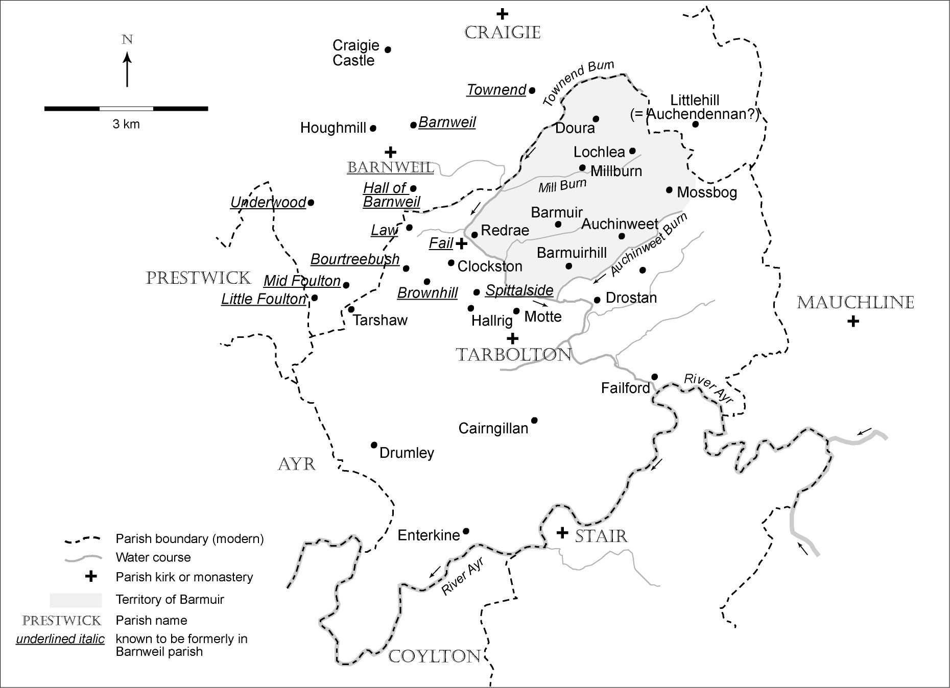
The question naturally arises as to where this parish was. As no other reference to Balinclog survives, we must look to the territory which our charters call Barmor. As the teinds of Barmor belonged to the rector of Balinclog, we know that the parish of Balinclog must have contained at least this territory. The name Barmor appears to represent Gaelic bàrr mòr, 'big hill'. It is not an uncommon name in Scotland, so that in itself does not help us to identify the place. But another charter, NAS GD 55/69 (published in Melrose Liber, no. 69), datable to 1189×1198, enables us to identify the relevant bàrr mòr with great precision. This records the donation of Richard Wallace (Ricardus le Walais) to Melrose Abbey of 'the land which is called Baremor', and it describes the bounds of the territory in detail:
Per has diuisas, scilicet ab hostio burne de Hactenewetne sursum usque ad caput eiusdem burne, et sic a capite burne sursum per quiddam uetus fossatum usque ad bog sub Hactenedonan, et sic deorsum sicut cruces facte sunt in quercus usque ad Louteuenan, et sic sursum uersus septemtrionem per uetus fossatum usque ad Polnecreihs, et sic deorsum sicut Polenecreihs descendit in Fale, et sic deorsum per Fale, usque ad hostium burne de Hactenewetne.
By these marches, that is from the mouth of the burn of Hactenewetne, up to the head of the burn, and from the head of the burn up by a certain old ditch as far as the bog below Hactenedonan, and so going down, as the crosses were made in the oak as far as Louteuenan, and then up towards the north by the old ditch as far as Polnecreihs, and so going down as Polnecreihs flows down into the Fale, and so down along the Fale as far as the mouth of the burn of Hactenewetne.
Though some of the names given in this perambulation do not survive, two of them do: the burn of Hactenewetne and the Fale are clearly the Auchineweet Burn and the Water of Fail, and so we are able to identify the eastern and southern marches of Melrose Liber's territory of Barmor with the modern place-name Barmuir, which now lies in the parish of Tarbolton in Ayrshire. We have thus been able to identify a lost parish of the thirteenth century, and to locate it. There remains the question about exactly what territory (apart from Barmuir, that is) the parish included, and when the parish might have disappeared, and why. I have no great insight into these questions. The parish of Tarbolton is itself not referred to, as far as I can see, until 1335, when Melrose Liber no. 447 shows John de Graham, lord of Tarbolton, giving the right of patronage of the church of Tarbolton (Torbolton') to his kinsman Robert de Graham and his heirs together with the land of Unthank (Wnzank) on which the church is built. It is possible that the parish of Tarbolton was, in 1335, simply the same parish as that of Balinclog, now called by a new name. It may be, on the other hand, that the old parish of Balinclog had once largely comprised lands which later became part of the lands of the parish of Barnweil (also now defunct, as of 1673) which lay to the west of Barmuir, and included Foulton, Bourtreebush, Underwood, Barnweil (all now in Craigie parish) and Brownhill, Fail, and Spittalside (now in the parish of Tarbolton). If this latter scenario is accepted, we might suspect that the parish of Balinclog disappeared when the Trinitarian monastery of Fail was established. It is not possible to say when the monastery of Fail was founded. It first appears in the surviving record in 1335 (Melrose Liber no. 447), but it may be many decades older than that. This foundation of Fail held the parish of Barnweil, which might in turn have been created as a patrimony for the Trinitarians by the dismembering of Balinclog, creating the parish of Barnweil and leaving a rump territory of Barmuir to be absorbed by Tarbolton parish.
Whatever the reason for its disappearance, there is no trace of Balinclog after its mention in the charters of 1226 – or nearly no trace. The name Balinclog seems to be Gaelic baile a' chluig (earlier baile in cloic), which means 'farm of the bell'. This kind of name is well known in Gaelic speaking areas, and is of a pattern which relates to the location of the relics (bells, books, crosiers, bones and so on) of saints and to the lands held by the hereditary keepers or 'dewars' (from Gaelic deòradh) of those relics.
Though the name Balinclog disappears after 1226, it may have left one trace. There is today a farm called Clockston a very short distance from the lands of Barmuir, in Tarbolton parish. This looks very much like a Scots name meaning 'farm of the bell', a perfect translation of Gaelic baile in cloic. If it is such a translation and if it is the same place as the original farm of Balinclog, it means that there was probably some ongoing recognition of the importance of the bell after which it was named, and of the dewar who had custody of it, in the early Scots-speaking period. Though I can find no reference to a farm called Clockston earlier than the horse-tax roll of 1797-8 (National Archives of Scotland, now on line at the very impressive) which lists Clockston as having two taxable horses, it may be that this farm represents the last echo of the ancient parish-name.
[This is a very much abbreviated version of a much fuller account of these charters, of the lands and bounds of Barmuir, the parish of Balinclog, and of the occurrence of Scottish parish-names in baile, which has appeared as 'Balinclog: a lost parish in Ayrshire', in The Journal of Scottish Name Studies 3 (2009) 47-64.]